Throughout the summer and fall of 2010, Krakatau erupted hundreds of times a day, but by November 17, when the Advanced Land Imager (ALI) on NASA’s Earth Observing-1 (EO-1) satellite took this image, activity at the volcano had started to slow. The image was taken as part of Volcano SensorWeb, a program that automatically schedules the ALI and Hyperion sensors on EO-1 to image volcanoes when other satellites detect signs of activity. ALI provides a detailed, photo-like view, useful for tracking ash, while Hyperion records the temperature and position of lava flows. Source : earthobservatory.nasa.gov
Read More... “Satellite Image of Krakatau, Indonesia” »»

The primary danger during the eruption at Merapi Volcano has been pyroclastic flows. These avalanches of hot volcanic gases, ash, and rocks descend rapidly and violently, occasionally at speeds over 150 kilometers (90 miles) per hour. Pyroclastic flows are usually channeled by the terrain, but large and violent flows can spread over a wide area.
This false-color satellite image from the ASTER instrument on NASA's Terra satellite shows evidence of a large pyroclastic flow along the Gendol River south of Mount Merapi. Light gray volcanic deposits (either from pyroclastic flows or lahars) fill the course of the Gendol. Just north of the Merapi Golf Course (light red feature) is a much wider area where a pyroclastic flow spread across the landscape, causing almost total devastation. Within this dark gray area, most of the trees were knocked down and the ground was coated by ash and rock. The flow deposits are largely surrounded by healthy vegetation, colored bright red. A light gray ash plume extends the west of the volcano, guided by the prevailing winds. Near the plume, heavy ashfall has coated the fields and forests, coloring them dull red to gray. Source: earthobservatory.nasa.gov
Although the oil visible in this image appears fairly distant from the coastline, NatureNews reported that the western edge of the slick had been brushing up against the Mississippi Delta since April 30. Model predictions put the oil slick near the coast of Louisiana by May 4 or 5, but changing winds pushed the oil farther away from land on May 4. Ecologists still worried, however, that the oil might drift into the path of the Loop Current, which carries warm water from the Yucatán Peninsula across the Gulf of Mexico and toward Florida. The current had the potential to spread oil to the shores to Mississippi, Alabama, the east coast of Florida, and the Florida Keys.
The European Space Agency's (ESA) Envisat saltellite has captured the changes in direction of the rapidly-growing oil spill in the Gulf of Mexico as strong winds pushed it around and hampered clean-up efforts.
In these images, the oil spill is visible due east of the Delta National Wildlife Refuge extending into the Gulf. The white dots are oil rigs and ships.
Wind can easily spread oil on the water, with the course determined by the wind's direction and speed. Following the explosion of the drilling rig on 22 April that produced the oil leak, the winds were blowing west-northwest. On Saturday winds were blowing from the southeast, pushing the slick toward Louisiana.
Radar
Radar is especially suited for detecting oil spills because it works day and night, can see through clouds (unlike optical sensors) and is particularly sensitive to the smoother water surface caused by the oil. Depending on the situation, oil is harder to detect in optical satellite observations because the surface changes are not as pronounced.
In this radar image, acquired from Envisat's Advanced Synthetic Aperture Radar (ASAR) on 2 May 2010 03:45 UTC (Saturday night local time), the oil spill is visible due east of the Delta National Wildlife
Refuge extending into the Gulf of Mexico. The white dots are oil rigs and ships. Radar is especiallysuited for detecting oil spills because it works day and night, can see through clouds (unlike optical sensors) and is particularly sensitive to the smoother water surface caused by the oil. Read More... “Satellite image of Louisiana oil spill” »»
Here’s our list of the 7 animals with the longest life spans. Tuataras
The word “dinosaur” is commonly used to describe an old person, but when it refers to a tuataras, the term is as literal as it is metaphorical. The two species of tuatara alive today are the only surviving members of an order which flourished about 200 million years ago — they are living dinosaurs. They are also among the longest-lived vertebrates on Earth, with some individuals living for anywhere between 100 and 200 years.
Lamellibrachia tube worms
These colorful deep sea creatures are tube worms (L. luymesi) that live along hydrocarbon vents on the ocean floor. They have been known to live 170 years, but many scientists believe there may be some that have lived for more than 250 years. Red sea urchins
The red sea urchin or Strongylocentrotus franciscanus is found only in the Pacific Ocean, primarily along the West Coast of North America. It lives in shallow, sometimes rocky, waters from the low-tide line down to to 90 meters, but they stay out of extremely wavy areas. They crawl along the ocean floor using their spines as stilts. If you discover one, remember to respect your elders — some specimens are more than 200 years old. Koi
Koi
Koi are an ornamental, domesticated variety of the common carp. The are common in artificial rock pools and decorative ponds. Amazingly, some varieties are capable of living more than 200 years. The oldest known koi was Hanako, a fish that died at the age of 226. Tortoises
Tortoises are considered the longest living vertebrates on Earth. One of their oldest known representatives was Harriet, a Galapagos tortoise that died of heart failure at the age of 175 years in June 2006 at a zoo owned by the late Steve Irwin. Harriet was considered the last living representative of Darwin’s epic voyage on the HMS Beagle. An Aldabra giant tortoise named Adwaita died at the rumored age of 250. Ocean quahog
The ocean quahog (Arctica islandica) is a species of clam that is exploited commercially. Researchers have interpreted the dark concentric rings or bands on the shell as annual marks, much like a tree has rings. –Some collected specimens have been calculated to be more than 400 years old.
Geoducks
First on the list are these large saltwater clams that are native to the Puget Sound and have been known to live for at least 160 years. They are characterized by their long ‘necks’, or siphons, which can grow to over 1 meter long.
 The year 2009 is likely to rank in the top 10 warmest on record since the beginning of instrumental climate records in 1850, according to data sources compiled by the World Meteorological Organization (WMO). The global combined sea surface and land surface air temperature for 2009 (January–October) is currently estimated at 0.44°C ± 0.11°C (0.79°F ± 0.20°F) above the 1961–1990 annual average of 14.00°C/57.2°F. The current nominal ranking of 2009, which does not account for uncertainties in the annual averages, places it as the fifth-warmest year. The decade of the 2000s (2000–2009) was warmer than the decade spanning the 1990s (1990–1999), which in turn was warmer than the 1980s (1980–1989). More complete data for the remainder of the year 2009 will be analyzed at the beginning of 2010 to update the current assessment.
  This year above-normal temperatures were recorded in most parts of the continents. Only North America (United States and Canada) experienced conditions that were cooler than average. Given the current figures, large parts of southern Asia and central Africa are likely to have the warmest year on record.
Climate extremes, including devastating floods, severe droughts, snowstorms, heat waves and cold waves, were recorded in many parts of the world. This year the extreme warm events were more frequent and intense in southern South America, Australia and southern Asia, in particular. La Niña conditions shifted into a warm-phase El Niño-Southern Oscillation (ENSO) in June. The Arctic sea ice extent during the melt season ranked the third lowest, after the lowest and second-lowest records set in 2007 and 2008, respectively.
Regional temperature anomalies
The year 2009 (January–October) was again warmer than the 1961–1990 average all over Europe and the Middle East. The year started with a mild January in northern Europe and large parts of Asia, while western and central Europe was colder than normal. The European summer was also warmer than the long-term average, particularly over the southern regions. A heat wave at the beginning of July affected the United Kingdom, France, Belgium and Germany, and some stations in Norway experienced new maximum temperature records.
India had an extreme heat wave event during May, which caused 150 deaths. A heat wave hit northern China during June, with daily maximum temperatures above 40°C; historical maximum temperature records were broken for the summer in some locations.
The austral autumn (March to May) was extremely warm in Argentina, Uruguay, Paraguay and southern Brazil. With daily temperatures ranging from 30°C to 40°C, several records were broken during this season.
So far, Australia has had the third-warmest year on record. The year 2009 was marked by three exceptional heat waves, which affected south-eastern Australia in January/February and November, and subtropical eastern Australia in August. The January/February heat wave was associated with disastrous bushfires that caused more than 173 fatalities.
Severe droughts
China suffered its worst drought in five decades. Water levels in parts of the Gan River and Xiangjiang River were the lowest in the past 50 years. In India the poor monsoon season caused severe drought impacts in 40 per cent of the districts. The north-western and north-eastern parts of the country were badly affected. It was reported to be one of the weakest monsoon seasons since 1972.
In North America, Mexico experienced severe-to-exceptional drought conditions by the month of September. In the United States, the western region was the most affected by a moderate-to-exceptional drought by the end of October. Nevertheless, the total area affected by drought in the United States during October was the second-smallest value recorded in this decade.
Drought in Central Argentina caused severe damage to agriculture, livestock and water resources. The situation was most severe at the end of October, with very high temperatures reported as well.
Over the key agricultural areas of the Murray-Darling Basin and the south-western part of Western Australia, rainfall was generally below normal. The passage of another year without any sustained above-normal rainfall has seen long-term rainfall deficits continuing in south-eastern Australia. Sustained dry conditions in the Murray-Darling Basin have now continued for nine years.
End of La Niña and Development of El Niño
La Niña-like conditions were present in early 2009, followed by the development of El Niño patterns starting in June 2009. During June–September 2009, sea surface temperatures were generally about 1°C warmer than the long-term average across the central and eastern equatorial Pacific. An El Niño event is currently underway, with the early phase of the event holding steady at weak-to-moderate levels through July–September. During October, almost all indicators of El Niño became noticeably stronger.
Tropical cyclone season
The 2009 Atlantic hurricane season closed with the fewest named storms and hurricanes since 1997, most likely due to the unfavorable cyclonic conditions caused in part by El Niño. A total of nine named tropical storms were formed, including three hurricanes, two of which were major hurricanes at Category 3 strength or higher.
In the East Pacific, 20 named tropical storms were recorded, eight of which evolved into hurricanes and five of which became major hurricanes.
In the western North Pacific, 22 named tropical storms have been recorded so far, and 13 of them reached the intensity of typhoon, compared to the long-term averages of 27 and 14, respectively.
The Australian and South Indian Ocean cyclone seasons recorded near-average activity. In the Australian region, there were 10 systems during this season, with Hamish the most significant one, although it did not make landfall. It reached category 5 intensity and was the most intense cyclone observed off the eastern Queensland coast since 1918.
Third-lowest Arctic sea ice
According to scientific measurements, Arctic sea ice has declined dramatically over the past 30 years at least, with the most extreme decline seen in the summer melt season. Arctic sea ice extent during the 2009 melt season was 5.10 million km2, which is the third-lowest on record after the 2007 record (4.3 million km2) and 2008 (4.67 million km2), since satellite measurements began in 1979.WMO
 It is difficult to believe in this day in age, with all that we know about sharks' plummeting populations, their critical role in ocean ecosystems and the minimal risk they pose to humans, that the archaic and destructive practice of installing shark nets for "bather protection" still exists. But in KwaZulu-Natal (KZN), South Africa, a province ironically known around the world as one of the few places left where sharks and the ecosystems they keep healthy still thrive, untold numbers of harmless sharks, turtles, dolphins, and rays meet an untimely and senseless death each year by entanglement in the approximately 28 kilometers of ‘shark' nets that are installed just off the beaches.
Over the last three decades, more than 33,000 sharks have been killed in the KZNSB shark nets. And if that's not alarming enough, 2,000+ turtles, 8,000+ rays, and 2,000+ dolphins were also ensnared and killed.
What are shark nets? Shark nets are essentially gill nets: long rectangular nylon mesh nets, 200-300 metres in length, that are positioned near the surface of the water and kept afloat with buoys. Sharks swim into these nets and are caught by their gills. The squares of mesh are designed to be just large enough for sharks to become entangled, but not escape. The more a shark or any other animal struggles in these nets, the more hopeless their situation becomes, and the more impossible their chances of escape and survival. The vast majority of these animals die an agonizing death by suffocation. Gill nets are widely considered to be one of the greatest threats to the survival of many species of marine animals.
33% of sharks in nets were leaving beaches!
In South Africa, the shark nets are installed in tiered patterns by the KwaZulu-Natal Sharks Board (KZNSB). Just beneath the surface, they do not fully extend to either the top or the bottom and do not even come close to fully enclosing the beach areas. The result is that sharks can easily swim around or under the nets and into the shallow waters in which humans swim and surf. In fact, the KZNSB acknowledges on its own website that at least 33% of the sharks killed in these nets were actually on their way OUT from the beaches, rather than on their way in, and other sources estimate that this number is closer to 70%.
Bait is set to attract sharks
You see, the goal is not to provide a physical barrier to keep sharks away from the beaches, but rather to control shark populations by culling them. In many cases, the KZNSB places baited drumlines just outside the shark nets, which are designed to attract sharks in towards the beaches and kill them, either by biting the baited hooks on the drumlines or by entanglement in the nearby gill nets.
Nets installed in Marine Protected Areas!
The process is entirely unselective, with nets installed all along the coast, including in Marine Protected Areas! The sole purpose of these nets is to kill all sharks in the area, including highly endangered species that would otherwise enjoy stringent legal protection, such as whale sharks and the great white shark.
Brutal, indiscriminate killers
Sharks and other animals don't stand a chance against these nets. They are brutal, indiscriminate killers designed to systematically cull a species for no other reason than to boost tourism by giving beachgoers a false sense of security against a severely sensationalized threat.
Shark tourism
Sharks in South Africa contribute a significant amount of revenue to the South African economy and provide countless jobs. Live sharks mean tourists, jobs, and money. And that is recurring income-not the one-time income generated when a shark is killed.
Shark populations endangered
But since then, shark fishing has skyrocketed, eliminating a large percentage of the world's shark populations, and the public has been exposed too much information about the importance of biodiversity conservation and the true nature of shark behavior towards humans. In recent years, it has been proven that a variety of non-lethal shark deterrents, such as the Shark Spotters program funded by private donations and the City of Cape Town, can be equally effective, and that animals need not be killed to allow for peaceful coexistence in their domain. The need for shark conservation is now a well-established fact, as is the fact these animals are significantly misunderstood, with the actual risk of an unpleasant shark encounter infinitesimal.
 Typhoon Melor is forecasted to strike the city on Thursday and weather forecasters have made warnings about strong winds and high waves in the sea. Typhoon Melor was swirling with speed of 252 kilometers per hour (156 miles/hr) and bore down in the island of Minami Daito. Typhoon Melor has now slowed down from a Super Typhoon. the Joint Typhoon Warning Center warned of sustained winds of 85 knots (98 mph) and gusts up to 105 knots (121 mph) and waves up to 33 feet (10 meters).
The eye of the storm was completely clouded, and the iconic bands of spiraling clouds that characterize strong typhoons appeared to be blending into a more disorganized deck of clouds and thunderstorms, especially in the northern half of the storm.
The weather agency of Japan has forecasted that the typhoon will have a speed of 180 kilometers per hour near its center. An official at the weather agency has warned the residents that the typhoon will bring furious winds and the sea waves can rise up to 80 meters. Though Japan’s buildings are now stronger than it were in past, weather forecasters have issued warnings to the natives as the violent typhoon may claim deaths. Melor means Jasmine in Malay language. The typhoon Melor will follow the route similar to the deadly typhoon of year 1959; however typhoon Melor is not expected to cause damage on a very big scale. The weather agency has raised a warning of scale 3 which means the cyclone may wreck landslides and flash floods.
 The Lesser Sunda islands stretch out across this image captured by the MODIS on the Terra satellite on August 18, 2009. These islands form the southern border of Indonesia with Australia. The grouping is spread across 1,200 kilometers from the western island of Lombok on the left to the eastern tip of Timor, the largest island in the image. The Islands are surrounded by the waters of the Indian Ocean as well as the Flores, Banda, Sawu, and Timor Seas.
In a few places, bright turquoise-blue spots on the water mark tiny islands surrounded by shallow waters: the Kepulauan Taka´Bonerate islands to the north, the Kepulauan Tukangbesi islands to the northeast, and the Ashmore and Cartier Islands (Australian territories) to the south.
There are a few active fires through the islands - each fire is marked with a red dot. Modis-NASA
 August 12 - 20, 2009, Manado, North Sulawesi, Indonesia.
Come and join in the international event Sail Bunaken 2009 for sharing new experience and exploring the marine beauty along with the marine lovers from all over the world in a spirit of adventure, graced by the marine paradise of Bunaken Sea.
Sail Bunaken 2009 offers various marine activities, including Indonesian Fleet Review, Yacht Rally, Bunaken Expo & Festival, International Big Game Fishing "KASAL CUP", Diving Competition & Festival, International Seafood Festival, and Bunaken Trans Equatouring Celebes 2009.
World Diving Record Broken at Sail Bunaken
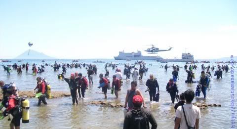
Nearly 3,000 divers set a world record Sunday for the largest group dive by plunging into the famed waters of Bunaken, North Sulawesi.
The information center of the Sail Bunaken 2009 committee said 2,818 people participated in the event, but only 2,805 people stayed underwater for at least 25 minutes. That is the minimum length of time required by the Guinness Book of Records, whose representatives were on hand to witness the new record.
Divers began entering the water at 8 in the morning. By midday, all of them had returned to shore. The mass dive also marked Indonesia's Independence Day, August 17. An Indonesian flag will be unfurled underwater as part of the independence celebrations.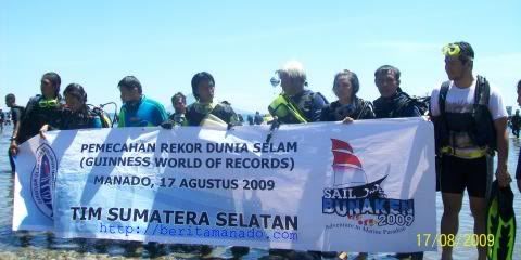
Sail Bunaken 2009 is a momentum to restore the image of Indonesia, as the largest maritime event in the world. This event involving dozens of countries with a war ship and sailor. This is the largest maritime event in 21st that held Sailing and Flying Pass various ships and war planes, an activity that is rarely done in the world. Sail Bunaken 2009 is jointly organized by the Ministry of Marine and Fishery Affairs, Provincial Administration of North Sulawesi, Ministry of Culture and Tourism, and Navy Force of Indonesia, supported by the Directorate General of Immigration and other government institutions.
There are two important issues related to implementation of the Sail Bunaken in North Sulawesi, which is the potential for marine biodiversity and resources of large, highly qualified converted to economic activity for the people. North Sulawesi province got momentum with a very prestigious event, so hopefully the local community able to support the activities. The natural beauty and marine diversity of Bunaken Sea Park in North Sulawesi have long been admired by marine lovers from all over the world, including divers, surfers, and tourists through to marine biodiversity researchers
Then, the Indonesian people can show the strength of defense and maritime security, so that it can not be regarded lightly by any country.
Route Sail Indonesia in Sail Bunaken 2009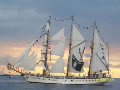
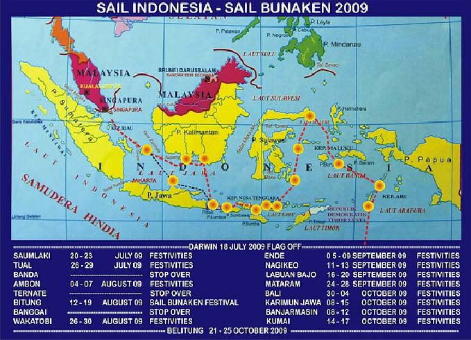
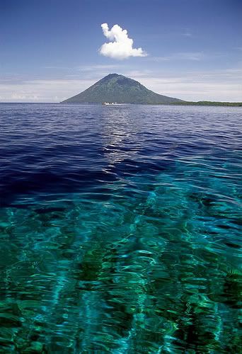 Bunaken is part of the Bunaken National Marine Park, which has some of the highest levels of marine biodiversity in the world. Bunaken is located at the north of the island of Sulawesi, Indonesia. It belongs administratively to the municipality of Manado.
The Bunaken National Marine Park was formally established in 1991 and is among the first of Indonesia's growing system of marine parks. The park covers a total surface area of 890.65 km², 97% of which is overlain by sparkling clear, warm tropical water. The remaining 3% of the park is terrestrial, including the five islands of Bunaken, Manado Tua, Mantehage, Nain and Siladen. Although each of these islands has a special character, it is the aquatic ecosystem that attracts most naturalists. The Park consists of a northern and southern section. The northern section includes five islands, and the coastal area between Molas to Tiwoho called the “Molas-Wori Coast”. Thesouthern section consists entirely of coastal area between Poopoh and Popareng villages, called the “Arakan-Wawontulap Coast”.
The Environment and Biodiversity Condition
The waters of Bunaken National Marine Park are extremely deep (1566 m in Manado Bay), clear (up to 35-40 m visibility), refreshing in temperature (27 to 29 °C) Pick any of group of interest - corals, fish, echinoderms or sponges - and the number of families, genera or species is bound to be astonishingly high. For example, 7 of the 8 species of giant clams that occur in the world occur in Bunaken. 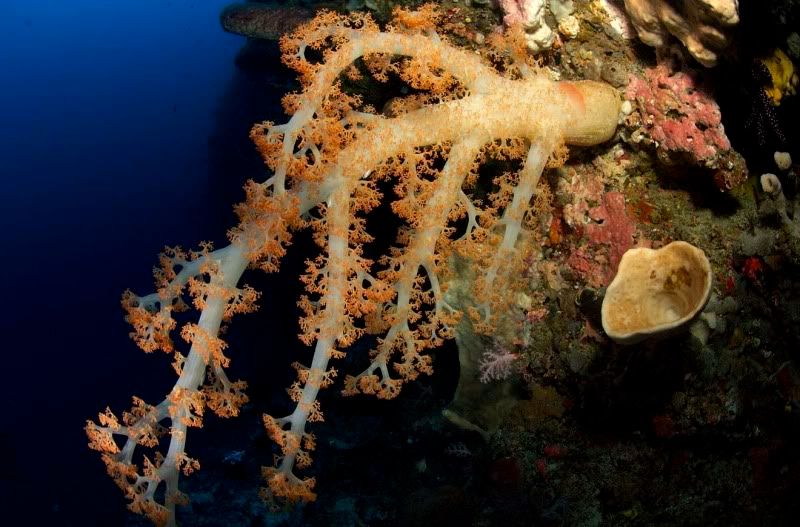 The park has around 70 genera of corals; compare this to a mere 10 in Hawaii. Although the exact number of fish species is unknown, it may be slightly higher than in the Philippines, where 2,500 species, or nearly 70% of all fish species known to the Indo-western Pacific, are found. A snorkler or diver in the vicinity of Lekuan or Fukui may spot over 33 species of butterfly fish and numerous types of groupers, damsels, wrasses and gobies. The gobies, smallish fish with bulging eyes and modified fins that allow them to attach to hard surfaces, are the most diverse but least known group of fish in the park
Biologists believe that the abundance of hard corals is crucial in maintaining the high levels of diversity in the park. Hard corals are the architects of the reefs, without them, numerous marine organisms would be homeless and hungry.
Bunaken Marine Park has become an important example of how Sulawesi, and the rest of Indonesia, can work to protect its natural resources.
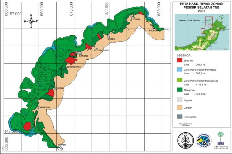
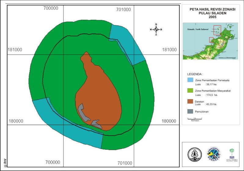
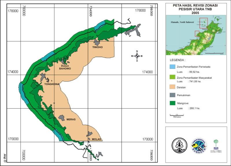
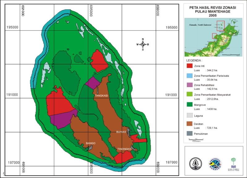
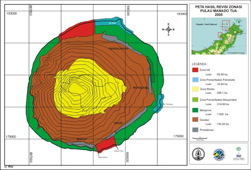
Zonation Map.